Appalachian Trail

The Appalachian Trail is a 2185.9 mile long footpath stretching from Springer Mountain, Georgia to Mount Katahdin, Maine. Every Spring, hikers from all over head to Georgia and start walking north, attempting to hike the whole trail in one season. This is called a thru-hike. Only about 25% make it all of the way.

This blog follows our progress as we hike north.

Thursday, June 20, 2013

Halfway There

6/18 Tuesday 18.5 mi
The end of Maryland brought us to Pen-Mar County Park and the state line. Pen-Mar was an amusement park from 1880-1940 or so and operated by the railroad. A popular place in its day. Now, just some pavilions and picnic tables, a shell of its former self. It does still have an outstanding view, and the local pizza place delivers there. We got there around the end of our day and yes, we ordered a large supreme pizza and sat down and waited on it. It felt good. I browsed through the small park museum while charging our cell phone inside. We had the park mostly to ourselves, and a few other hikers came and went while we were there.
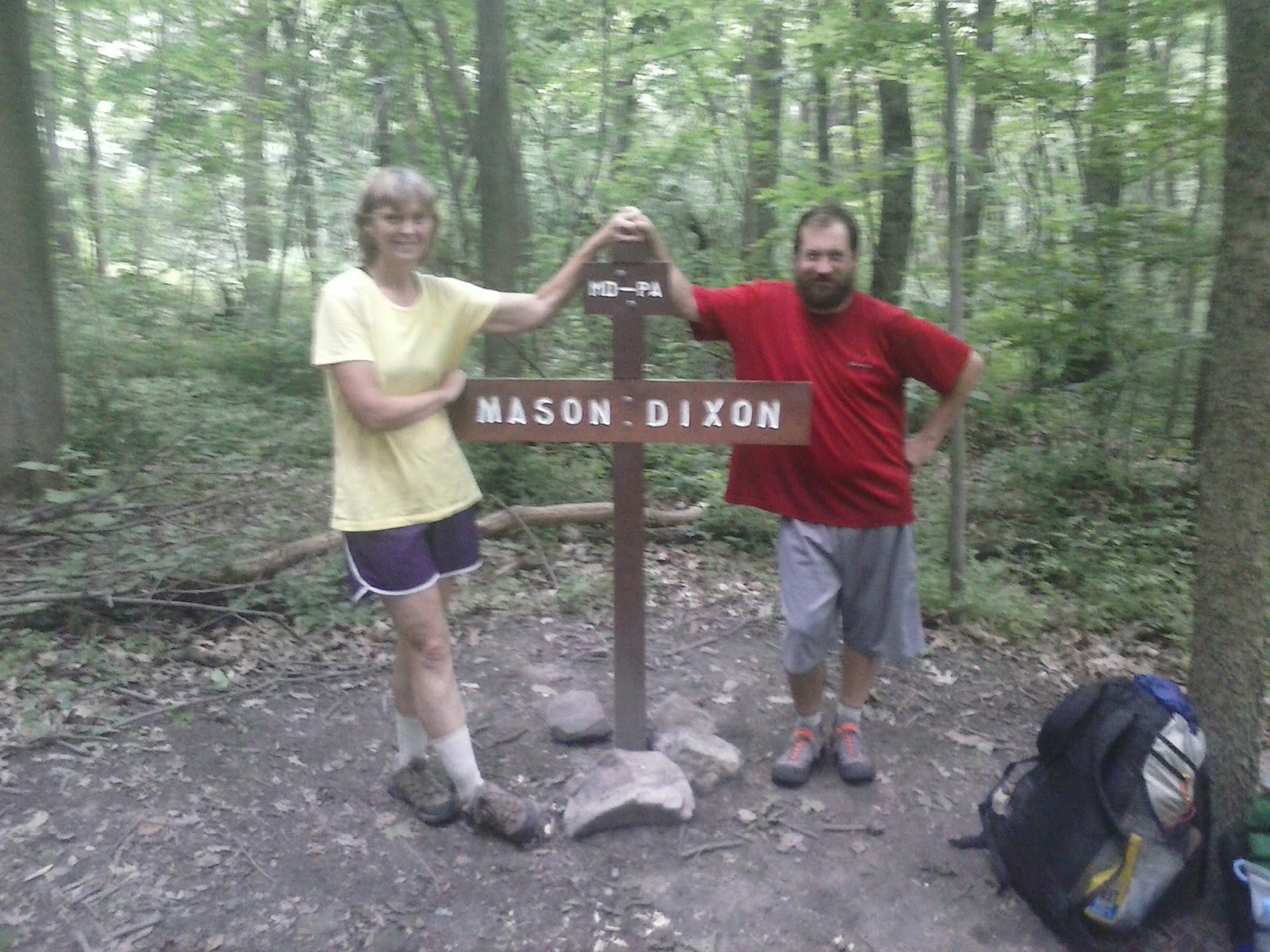
Immediately after Pen-Mar you come to the Mason-Dixon line, the border between Maryland and Pennsylvania. Named after the surveyors Charles Mason and Jeremiah Dixon, it took four years and solved a long time border dispute (sound smart, don't I? I should mention that was in the guidebook). We stopped for a picture, then stepped across into Pennsylvania. It felt as if we were finally done with the South. We had survived its tortures, and now we were in the North. We made it to Deer Lick Shelters and found a campsite for the night. (In Pennsylvania, for some reason, they like to build two smaller shelters instead of one larger one.)

6/19 Wednesday 13.2 mi
It rained unexpectedly hard overnight and got us wet, so we were not in the best of spirits the next day. We had so far easy walking in front of us, and made it to US 30 by late afternoon. We hitched into a nearby market to get a sandwich, and ended up caling the local motel to come and pick us up. We spent the night in Fayetteville PA, at a motel built in 1957, another relic of the past. There we met Tim and Kay, two locals who were helping run the place while the owner was away. They ended up cooking hamburgers and hot dogs for all of us that night, and were the best of hosts. We stayed up way too late, but didn't care.

6/20 Thursday 16.2 mi
We found breakfast at a restaurant across the street in the morning. Tim gave us a ride back to the trailhead, and we were on our way by 11 AM. There was a 1000' climb to start our day, but then after that it was pretty much level walking on top of the mountain. We made good time as the trail was not too rocky, either. Towards the end of our day we passed a campsite that is the halfway point on the trail this year. I say this year, because sections of the trail are rerouted from time to time, usually adding to the length of the trail (Well, they aren't going to make it any shorter!), which in turn changes the midpoint location. This year, it's at mile 1093.0 and is marked by some rocks spelling '1/2'. We made it another mile to Toms Run Shelters (again, two of them) and found a campsite with a stream nearby.

Currently at mile 1094.0

Tuesday, June 18, 2013

Maryland

What will we remember about Maryland? Easy-walking trails and snakes. Lots of snakes.
There is 40 miles of AT in Maryland, and the trail here is very clean and well taken care of. With the exception of some rocky stretches it is nearly all two lanes wide. If only they had some mountains here. There are no steep, extended climbs, and for the most part you are walking along relatively level trail. What you do have to watch out for is to not step on a snake as you are going along. We both had encounters with large Black snakes across the trail. There was even a Copperhead on the C&O Towpath.
The climb out of Harpers Ferry takes you to a ridgetop, and you travel along it for what seems like most of the state. There were a couple of views along the way, and the original Washington Monument is located here. There were several backpackers campgrounds and lots of people on the trail. All in all, an enjoyable experience. We made it through in 2 1/2 days.

Harpers Ferry, Part II

6/16 Sunday 12.0 mi
We spent the night at the EconoLodge in town. In the morning we wanted to stop by the Appalachian Trail Conservancy HQ office to get our picture taken for their records, a thru-hiker tradition. I also needed to stop by the outfitter in town to buy a new pair of shoes, as mine were starting to fall apart. They were bought in Hot Springs NC, way back at mile 270. We also wanted one last town meal before heading into the woods.
The historic part of Harpers Ferry "Lower Town" was much larger than we had expected, and there is a lot of historical buildings open to explore. You could spend a lot of time here looking around. In addition to the historic part, people come here because the AT passes right through town, and so does the C&O canal towpath (180 mile biking/hiking trail). The bike rental business was brisk this morning.
The outfitter is also located in Lower Town, and with the help of trail guru Baltimore Jack I was able to find a new pair of shoes.
Sometime around Noon we left town, crossed the Potomac River, and entered Maryland.

Saturday, June 15, 2013

Harpers Ferry, WV

6/12 - 6/15
57 miles

We arrived in Harpers Ferry, West Virginia, this morning after a short 5 mile hike into town. As far as hiking goes, it was a very exciting day. The mere fact that we were in West Virginia meant that we were no longer in Virginia, and that we had survived its 500 miles, the longest state on the AT. It also meant that we had passed the 1000 mile point on our hike, where we stopped to take our self portrait. Additionally, it also meant that we were done with a section of trail called the Roller Coaster, 14 miles of tightly packed ascents and descents. Virginia's last 'hurrah'.

Shenandoah National Park

6/4 - 6/10
108 miles

Tuesday, June 4, 2013

Upcoming Maildrop

On the horizon:
Waynesboro to Front Royal - 7 days - ETA 6/10
Front Royal to Harper's Ferry - 4 days - ETA 6/14

We will be sending our next resupply box to Harpers Ferry. If you would like to send us cookies, we would be glad to eat them! Use the format below for the shipping label. Send care packages to:

Mark Deebel / Kristie Collins
c/o Appalachian Trail Conservancy HQ
PO Box 807
Harpers Ferry WV 25425
Please hold for AT hiker.
ETA 6/14

Monday, June 3, 2013

Part II: Summer

We returned to the woods after the long weekend and found that we could no longer cling to the thought that it was still Spring. Summer had come to the mountains, with it's heat and bugs, and we could not stop it. All of the trees had leaves now, and the rhododendrons and mountain laurel were in bloom. It does not feel like we have been out here that long for it to be June already.

5/28 Tuesday 11.7 mi
We were dropped off back at the James River, where we had stopped on Friday. Wander's mother, daughter, and granddaughter were headed back home and it was sad to see them go. We didn't feel like going home with them, but neither of us particularly felt like walking. There was a 2500' climb waiting for us, which didn't help either.

5/29 Wednesday 16.4 mi
Passed 800 miles today. We had an easy long downhill in the morning, and then a 3000' climb to Bald Knob in the afternoon. Made it to Hog Camp Gap for the night. Scarce water continues.

5/30 Thursday 14.3 mi
The trail stayed between 3500' and 4000' in elevation all day long, so it was a relatively easy day. We stopped and camped at The Priest, a rock formation at the end of the ridge.

5/31 Friday 13.8 mi
We started the morning by going over The Priest, down 3000', across the Tye River, and then back up 3000' over Three Ridges Mountain, then down 1200' to Maupin Field Shelter. With the warmer weather here I was glad to be done with Three Ridges, the last big climb on the AT in quite awhile. We saw our second rattlesnake on top of Three Ridges on our way down.

6/1 Saturday 1.7 mi
We saw this event called Trail Daze posted in shelters earlier in the week. It takes place today and is put on by a local brewpub. We happened to be in the right place at the right time, and so planned to catch a shuttle in the morning at Reed's Gap, less than 2 miles away. We arrived at the gap to find trail magic, and waited for a shuttle to the event with about 25 other thru hikers. Thru hikers got in for free and they had free camping, so we ended up spending the night. There were various vendors set up outside, including three local trail clubs, Backpacker magazine, and other hiking related booths. There were a lot of thru hikers there that we hadn't seen in a long time, so it was a good time. The brewpub had excellent food and beer, and there was live music outside. All just four miles away from the trail.

6/2 Sunday 14.1 mi
We survived the festival and what turned out to be a very windy night, got up early and hitched back to the trail. It was about 20 miles to Waynesboro yet, and originally we had planned on getting there today, but stopping at the festival now put us a day behind and low on food. I was looking at eating nothing but peanut butter for the day.
It was an easy hiking day in front of us, getting over Humpback Mountain looking like the hardest part, and the climb to it was gradual. We were both hungry though, and were rationing our last bits of food for the day. About five miles in, when we least expected it, we came to a road crossing and found trail magic. There, set up along the road, was a group of people set up to feed hikers. We sat down (experienced trail angels away provide chairs) and had watermelon shoved in our faces. There were coolers of drinks and I found a beer (hey, it was noon-ish). We were in time for the last of the breakfast round, and watched as they changed over to lunch mode. Of course we stayed. Shish-kebabs and baked potatos were for lunch, along with fruit, chips and cookies. There were about a dozen of us, and we were in awe. We stuck around as long as we could, but needed to make it closer to town, so thanked our hosts and went on our way. Stomachs full, the remaining day's miles went by easier. Only a day away from town we would have been fine, but it was a great relief to find food like that.
The rest of the afternoon, as if we needed more excitement, turned into Nature Day. By that I mean we saw two deer, a rattlesnake, and two black bears. This was the first time we saw a bear that didn't immediately run away from us. It watched us watch it. I even got my camera out and got some video.
We made it to the shelter five miles before town and called it a day.

6/3 Monday 5.2 mi
We were up early and had an easy and uneventful trip to Rockfish Gap, where we left the trail and hitched into Waynesboro, about four miles away. The usual town ritual of motel, shower, food, laundry, and grocery took place. An excellent Chinese buffet was found, and we were full for the night.
Waynesboro is at the southern end of Shenandoah National Park, and tomorrow we will start our journey across it. SNP is 108 miles long and we plan to take seven days.

Mile 857.5